
What is Balasore District of Odisha famous for?
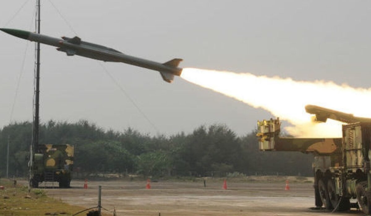
Balasore District of Odisha is primarily famous for its long 81-kilometer coastline along the Bay of Bengal and as a major rocket launch site for ISRO, making it India’s space gateway. As Odisha’s northernmost coastal district, it’s also known for its significant historical maritime trade, the scenic Subarnarekha River delta, and vibrant coastal culture. The district capital, Balasore town, is situated 204 km from Bhubaneswar.
Geographical Position:
The northernmost coastal district of Odisha, bordered by West Bengal’s Medinipur and the Bay of Bengal.
Key Attractions:
Known for Chandipur Beach with its unique receding tides, ISRO’s rocket launching facilities, and the Subarnarekha river delta.
Major Rivers:
Drained by five principal rivers: Subarnarekha, Budhabalanga, Jalaka, Kansabansa, and Sono.
Economic Hub:
Historically a major maritime trade center, with modern industries including defense, space research, and fishing.
Historical & Geographical Significance:
Balasore’s strategic location has shaped its destiny for centuries. Its 81 km coastline and position as a gateway between Odisha and West Bengal made it a bustling port for European traders, including the English, Dutch, and French. This maritime legacy is etched into its geography, where five major rivers, most notably the Subarnarekha, flow into the Bay of Bengal, creating fertile plains and unique ecosystems like the vanishing sea at Chandipur Beach.
Climatic Patterns & River Systems:
Balasore experiences a distinct coastal climate. Summers can be intensely hot, peaking in May with temperatures historically reaching 44°C. The monsoon arrives predictably around mid-June, delivering an annual average of 1568 mm of rainfall. The district’s lifelines are its rivers, especially the Subarnarekha. While vital for irrigation, this river system is largely unembanked, meaning its seasonal floods historically shape the landscape and agriculture of blocks like Jaleswar, Bhograi, and Baliapal.
Modern Identity & Space Frontier:
Today, Balasore is a district where rich history converges with cutting-edge science. It is globally recognized for hosting critical facilities of the Indian Space Research Organisation (ISRO), serving as a premier satellite and rocket launch base. This modern scientific identity complements its traditional economic pillars of fishing and agriculture, creating a unique blend of the ancient and the futuristic along its scenic shores.
Local Life & Unexplored Gems:
Beyond the beaches and launch pads, Balasore offers a vibrant cultural experience. The local markets are famous for seafood and traditional Balasore sweets. For explorers, the district holds hidden historical sites linked to its colonial past, serene boat rides on the Budhabalanga River, and the less-visited estuarine landscapes where the Jalaka and Kansabansa rivers meet the sea, offering peaceful retreats.
Balasore is one of the coastal district of Orissa, lies on the northern most part of the state having 21 degree 03′ to 21 degree 59′ North Latitude & 86 degree 20′ to 87 degree 29′ East Longitude. It is bounded by Bay of Bengal in the East, Mayurbhanj district in the West, Midnapore (W.B.) district in the North and Bhadrak district in the South. It has a massive coast line of 81 kms. The district head quarter, Balasore is 204 kms from the State Capital, Bhubaneswar.
Climate and Rainfall
Climate of the district is generally not with high humidity. May is usually the hottest month. Occurrence of large number of fire accidents is a regular feature of the district during the summer months i.e. April to May. December is the coolest month of the year. The highest maximum temperature recorded at Balasore was 44° C on 8.6.98. Monsoon generally commences from 14th June every year. Average rainfall of the undivided district is 1568.4 mm. The rainfall during June to December constitutes at least 75% of the annual rainfall of the district. There are average 62 rainy days in a year in the district.
River Systems and Dams
The district of Balasore has given ways to the following rivers.
- Subarnarekha
- Budhabalanga
- Jalaka
- Kansabansa
- Sono
The detail information about these rivers are given below:
River Subarnarekha
Gauge point : Rajghat
Warning Level : 9.45 metre/12.00ft
Danger Level : 1.56 metre/15.00ft
Highest Level : 20.80ft(16.10.85) and 12.20 Meters(7.8.98)
The river Subarnarekha originates from Chhotnagpur hill of Bihar State and enters Balasore district near Olmara of Jaleswar block. Expect some small strips of embankments the river is mostly without embankments. The river falls in Bay of Bengal near Kirtania of Bhograi block. During flood, large areas of Jaleswar, Bhograi and Baliapal blocks and a small pocket of Basta block are affected.
Leave feedback about this
You must be logged in to post a comment.